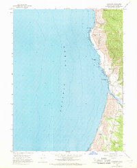
1966 Map of Inglenook
USGS Topo · Published 1968About this map
The Ten Mile River meets the coast in this mid-1960s study of the Mendocino shoreline, revealing a landscape defined by coastal bluffs and extensive Sand Dunes. The settlement of Inglenook sits just inland, anchored by the Grange Hall and Inglenook Cemetery, while the northern reaches show the smaller locales of Kibesillah and Newport. These small communities were established near rugged points and gulches, with the Newport Cemetery overlooking the ocean near Newport.
Find a feature on this map
24 named features on this map. Tap any name to fly to it.
Don’t see what you’re looking for? This feature index may not catch every label — zoom into the map to look around manually.
Map Details
Editions of this 1966 Inglenook Map
4 editions found
Other maps of this area

1920 · Glenblair
USGS Topo · 1:62,500

1920 · Fort Bragg
USGS Topo · 1:62,500

1921 · Westport
USGS Topo · 1:62,500

1921 · Branscomb
USGS Topo · 1:62,500

1943 · Glenblair
USGS Topo · 1:62,500

1943 · Fort Bragg
USGS Topo · 1:62,500

1950 · Cape Vizcaino
USGS Topo · 1:62,500

1951 · Cape Vizcaino
USGS Topo · 1:62,500

1951 · Branscomb
USGS Topo · 1:62,500

1957 · Ukiah
USGS Topo · 1:250,000