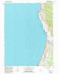
1966 Map of Inglenook
USGS Topo · Published 1994About this map
Kibesillah and Newport anchor this coastal stretch of Mendocino County, where the terrestrial landscape meets the Pacific Ocean along a series of dramatic bluffs and gulches. The settlement pattern is defined by small coastal clusters and family-named landmarks like Bell Mountain and Kibesillah Hill. The map provides significant genealogical value through the identification of the Newport Cemetery and Inglenook Cemetery, alongside the local Grange Hall.
Find a feature on this map
27 named features on this map. Tap any name to fly to it.
Don’t see what you’re looking for? This feature index may not catch every label — zoom into the map to look around manually.
Map Details
Editions of this 1966 Inglenook Map
4 editions found
Other maps of this area

1920 · Glenblair
USGS Topo · 1:62,500

1920 · Fort Bragg
USGS Topo · 1:62,500

1921 · Westport
USGS Topo · 1:62,500

1921 · Branscomb
USGS Topo · 1:62,500

1943 · Glenblair
USGS Topo · 1:62,500

1943 · Fort Bragg
USGS Topo · 1:62,500

1950 · Cape Vizcaino
USGS Topo · 1:62,500

1951 · Cape Vizcaino
USGS Topo · 1:62,500

1951 · Branscomb
USGS Topo · 1:62,500

1957 · Ukiah
USGS Topo · 1:250,000