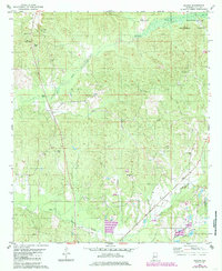
1980 Map of Ingram
USGS Topo · Published 1985About this map
Talladega National Forest encompasses the northeastern portion of this landscape in Hale County, where the terrain transitions into a series of ridges and creek valleys. The area is defined by its numerous rural congregations, including Puritt Spring Ch, Macedonia Ch, and Rhodes Chapel, illustrating a deeply rooted community structure. Local industry and infrastructure are represented by the Gaging Station and several Gravel Pits north of Harper Hill. Drainage is dominated by the winding path of Fivemile Creek, while the southern reaches are marked by Big Brush Creek and Little Brush Creek. The settlement of Ingram sits near the northern boundary, while scattered family cemeteries like Chambers Cem and Shelton Cem provide valuable evidence for genealogical research.
Find a feature on this map
28 named features on this map. Tap any name to fly to it.
Don’t see what you’re looking for? This feature index may not catch every label — zoom into the map to look around manually.
Map Details
Editions of this 1980 Ingram Map
2 editions found
Other maps of this area

1953 · Montgomery
USGS Topo · 1:250,000

1956 · Montgomery
USGS Topo · 1:250,000

1957 · Montgomery
USGS Topo · 1:250,000

1979 · Morgan Springs
USGS Topo · 1:24,000

1979 · Greensboro
USGS Topo · 1:24,000

1980 · Payne Lake
USGS Topo · 1:24,000

1980 · Ingram
USGS Topo · 1:24,000
1980 · Moundville West
USGS Topo · 1:24,000
1980 · Sawyerville
USGS Topo · 1:24,000
1980 · Hogglesville
USGS Topo · 1:24,000