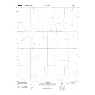
2010 Map of Ingram Lake
USGS Topo · Published 2010About this map
Sauz Creek and Anderson Draw carve through this high plains section of Colfax County, defining a landscape marked by ranching infrastructure and intermittent water sources. In the early 21st century, this area maintained a sparse settlement pattern anchored by small locales such as Jeffers and Bada. The hydrology is centered on Ingram Lake and Decker Dam, reflecting the critical importance of water management in this arid environment. Roads like the historically named Point Of Rocks Rd and County Road C-57 follow the section lines of the survey grid, connecting isolated homesteads to the wider region. The most prominent topographical landmark is Sombrero Butte, which rises distinctly in the northeast, serving as a natural waypoint for travelers moving across the open range.
Find a feature on this map
21 named features on this map. Tap any name to fly to it.
Don’t see what you’re looking for? This feature index may not catch every label — zoom into the map to look around manually.
Map Details
Editions of this 2010 Ingram Lake Map
This is the sole edition of this map. No revisions or reprints were ever made.
Other maps of this area
1954 · Raton
USGS Topo · 1:250,000
1958 · Raton
USGS Topo · 1:250,000
1965 · Sauble Circle Dot Ranch
USGS Topo · 1:24,000
1965 · Abbott
USGS Topo · 1:24,000
1971 · Abbott Lake
USGS Topo · 1:24,000
1974 · Point Of Rocks Mesa
USGS Topo · 1:24,000
1974 · Farley
USGS Topo · 1:24,000
1974 · Lawrence Arroyo
USGS Topo · 1:24,000
1974 · Spear Hills
USGS Topo · 1:24,000
1974 · Divine Lake
USGS Topo · 1:24,000