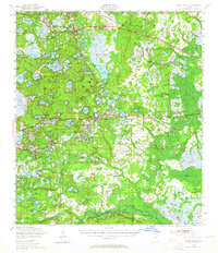
1949 Map of Interlachen
USGS Topo · Published 1965About this map
Lake Grandin and an intricate network of freshwater bodies dominate this 1949 landscape in Florida's lake region. The map captures the area before modern development, showing established settlements like Interlachen and Florahome connected by the Atlantic Coast Line and Southern Ry railroads. The presence of Peat Cutting operations near Grandin and Florahome reveals the specialized local industries of the era, while the southern boundary includes the northern edge of the Ocala National Forest and the winding course of Orange Creek. Local heritage is preserved through landmarks like Agnew Landing and Cedar Landing on the Orange Creek and Ocklawaha River corridor, alongside numerous small lakes such as Lake Loyal and Swan Lake. This survey illustrates the transition from river-and-rail commerce to the post-war road network in Putnam and Marion counties.
Find a feature on this map
95 named features on this map. Tap any name to fly to it.
Don’t see what you’re looking for? This feature index may not catch every label — zoom into the map to look around manually.
Map Details
Editions of this 1949 Interlachen Map
3 editions found

Other maps of this area

1893 · Citra
USGS Topo · 1:62,500

1895 · Citra
USGS Topo · 1:62,500

1912 · Palatka
USGS Topo · 1:48,000

1915 · Palatka
USGS Topo · 1:62,500

1915 · Interlachen
USGS Topo · 1:48,000

1916 · Interlachen
USGS Topo · 1:62,500

1938 · Hawthorn
USGS Topo · 1:48,000

1941 · Starke
USGS Topo · 1:62,500

1942 · Ates Creek
USGS Topo · 1:62,500

1943 · Hawthorn
USGS Topo · 1:62,500