
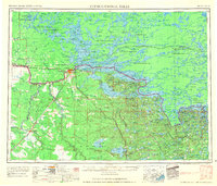
1958 Map of International Falls
USGS Topo · Published 1958About this map
International Falls and its Canadian neighbor Fort Frances serve as the primary gateway between Minnesota and Ontario in this mid-century survey of the Northwoods. The Rainy River defines the international boundary, connecting the expansive waters of Rainy Lake to the eastern edge of the Lake of the Woods watershed. The landscape is a complex maze of water and timberland, including the Nett Lake Indian Reservation and numerous smaller reserves like Rainy Lake Indian Reserve No 17B scattered along the northern shorelines.
Find a feature on this map
125 named features on this map. Tap any name to fly to it.
Don’t see what you’re looking for? This feature index may not catch every label — zoom into the map to look around manually.
Map Details
Editions of this 1958 International Falls Map
2 editions found
Other maps of this area

1918 · Zora
USGS Topo · 1:62,500

1919 · Zora
USGS Topo · 1:62,500

1919 · Lundgren
USGS Topo · 1:62,500

1919 · Gemmell
USGS Topo · 1:62,500

1919 · Pelland
USGS Topo · 1:62,500

1919 · Birchdale
USGS Topo · 1:62,500

1919 · I
USGS Topo · 1:62,500

1919 · Happy Land
USGS Topo · 1:62,500

1919 · M
USGS Topo · 1:62,500

1919 · Margie
USGS Topo · 1:62,500