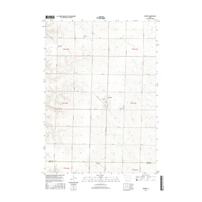
2015 Map of Inwood
USGS Topo · Published 2015About this map
Inwood serves as the central hub of this agricultural landscape in northwestern Iowa, where a strictly defined section-line road grid organizes the fertile terrain of Lyon and Sioux Counties. The map reveals a community deeply rooted in its local heritage, evidenced by several rural burial grounds that dot the countryside, including Bethlehem Cem, Richland Cem, and Our Saviors Lutheran Cem. These sites, along with the Bragstad Family Cem near the southern border, provide significant points of interest for genealogists tracing early families. The natural drainage of the region is defined by the winding paths of Dry Run Cr and Nelson Cr, which break the geometric precision of the farm-to-market road network. This network, featuring arterial routes like Co Hwy K12 and Co Hwy A34, illustrates the enduring infrastructure required to support the local grain and livestock economy.
Find a feature on this map
38 named features on this map. Tap any name to fly to it.
Don’t see what you’re looking for? This feature index may not catch every label — zoom into the map to look around manually.
Map Details
Editions of this 2015 Inwood Map
This is the sole edition of this map. No revisions or reprints were ever made.
Other maps of this area

1897 · Canton
USGS Topo · 1:125,000

1900 · Canton
USGS Topo · 1:125,000

1955 · Sioux Falls
USGS Topo · 1:250,000

1958 · Sioux Falls
USGS Topo · 1:250,000

1962 · Klondike
USGS Topo · 1:24,000

1962 · Canton
USGS Topo · 1:24,000

1968 · Alcester NE
USGS Topo · 1:24,000

1968 · Fairview
USGS Topo · 1:24,000
1968 · Rock Valley
USGS Topo · 1:24,000

1971 · Lester
USGS Topo · 1:24,000