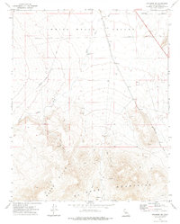
1972 Map of Inyokern SE
USGS Topo · Published 1975About this map
The Indian Wells Valley occupies the northern half of this 1970s survey, meeting the sharp rise of the El Paso Mountains and the Black Hills to the south. The arid landscape is defined by drainage patterns like Little Dixie Wash, which cuts across the valley floor toward the Southern Pacific railroad line. Evidence of human activity is scattered throughout the high desert, from the ancient Petroglyphs recorded in the southern peaks to contemporary industrial and utility markers like the Inyo Well (Dry) and several Prospect sites. A network of Jeep Trails and unnamed Trails laces through the canyons and ridges of the El Paso range, providing access to remote terrain between West Bowman Road and the mountain foothills. This edition captures the desert's character at a time when traditional transportation routes like the railroad remained central to the regional geography.
Find a feature on this map
15 named features on this map. Tap any name to fly to it.
Don’t see what you’re looking for? This feature index may not catch every label — zoom into the map to look around manually.
Map Details
Editions of this 1972 Inyokern SE Map
This is the sole edition of this map. No revisions or reprints were ever made.
Other maps of this area

1903 · Randsburg
USGS Topo · 1:62,500

1911 · Randsburg
USGS Topo · 1:62,500

1912 · Randsburg
USGS Topo · 1:62,500

1915 · Searles Lake
USGS Topo · 1:250,000

1943 · Inyokern
USGS Topo · 1:62,500

1943 · Saltdale
USGS Topo · 1:62,500

1947 · Trona
USGS Topo · 1:250,000

1948 · Trona
USGS Topo · 1:250,000

1953 · Ridgecrest
USGS Topo · 1:62,500

1953 · Trona
USGS Topo · 1:250,000