
1944 Map of Iona
USGS Topo · Published 1944About this map
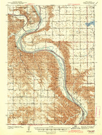
The confluence of the White River and the Missouri River anchors this 1940s landscape, revealing a rural network defined by its proximity to these major waterways. The community of Iona sits inland among the bluffs, surrounded by a dense distribution of one-room schoolhouses that once served these remote townships, including Lincoln Sch, Star Sch, and the Dobbins Sch (abandoned). The reliance on groundwater is evident through numerous Artesian Wells and Artesian Well markers scattered across the uplands and the river bottoms of Tom s Bottoms. Large landforms like Bailey Island and Philips Island remain prominent features within the Missouri channel, while local infrastructure is represented by the Grandview Cem and Franks Dam. The map captures a moment when small rural districts were the primary social unit, evidenced by the dozen or more named schools and the centrally located Iona Cem.
Find a feature on this map
45 named features on this map. Tap any name to fly to it.
Don’t see what you’re looking for? This feature index may not catch every label — zoom into the map to look around manually.
Map Details
Editions of this 1944 Iona Map
2 editions found
Other maps of this area

1935 · Chamberlain
USGS Topo · 1:62,500

1939 · Chamberlain
USGS Topo · 1:62,500

1940 · Iona
USGS Topo · 1:62,500

1941 · Pukwana
USGS Topo · 1:62,500

1951 · Pukwana
USGS Topo · 1:62,500

1952 · Reliance SE
USGS Topo · 1:24,000

1952 · Hamill NE
USGS Topo · 1:24,000

1952 · Oacoma
USGS Topo · 1:24,000

1952 · Iona NW
USGS Topo · 1:24,000

1955 · Mitchell
USGS Topo · 1:250,000