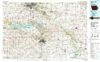
1984 Map of Iowa City
USGS Topo · Published 1989About this map
Cedar Rapids and Iowa City anchor this mid-1980s landscape, which centers on the river valleys of the Cedar River and the Iowa River. The influence of the University of Iowa is evident at the heart of Iowa City, while the surrounding countryside reflects a mix of intensive agriculture and conservation efforts. Significant recreational and wildlife areas, such as Lake Macbride State Park and the Hawkeye State Wildlife Management Area, illustrate the managed hydraulic environment of the Coralville Lake reservoir. Cultural heritage is quietly marked by the Amish Church in the southwest and Oakland Cem. Transportation networks are dominated by the I-80 corridor and several major rail lines, including the Chicago and North Western RR and the Chicago Rock Island and Pacific RR, which connect the industrial hubs of the region.
Find a feature on this map
162 named features on this map. Tap any name to fly to it.
Don’t see what you’re looking for? This feature index may not catch every label — zoom into the map to look around manually.
Map Details
Editions of this 1984 Iowa City Map
2 editions found
Other maps of this area

1887 · Cedar Rapids
USGS Topo · 1:62,500

1888 · Shellsburg
USGS Topo · 1:62,500

1888 · Marion
USGS Topo · 1:62,500

1888 · Amana
USGS Topo · 1:62,500

1889 · Tipton
USGS Topo · 1:62,500

1889 · Marion
USGS Topo · 1:62,500

1889 · Amana
USGS Topo · 1:62,500

1889 · Shellsburg
USGS Topo · 1:62,500

1890 · Durant
USGS Topo · 1:62,500

1890 · Tipton
USGS Topo · 1:62,500