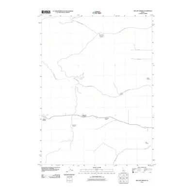
2010 Map of Ireland Springs
USGS Topo · Published 2010About this map
Ireland Springs and its surrounding water sources, including Lower Spring, Upper Spring, and Mud Spring, anchor this arid high-country landscape in Oneida County. The map documents a network of named canyons and hollows that define the local geography, such as Mansfield Canyon, Stump Canyon, and Hideaway Hollow. Transportation across this terrain is marked by remote corridors like John Evans Canyon Rd and Woods Canyon Rd, which navigate the elevation changes near Holbrook Summit. This 2010 survey illustrates the persistent importance of these named springs and topographical landmarks for land management and local navigation in a region where water and accessible passes dictate human movement.
Find a feature on this map
19 named features on this map. Tap any name to fly to it.
Don’t see what you’re looking for? This feature index may not catch every label — zoom into the map to look around manually.
Map Details
Editions of this 2010 Ireland Springs Map
This is the sole edition of this map. No revisions or reprints were ever made.
Other maps of this area

1954 · Pocatello
USGS Topo · 1:250,000

1958 · Pocatello
USGS Topo · 1:250,000

1963 · Daniels
USGS Topo · 1:24,000

1968 · Ireland Springs
USGS Topo · 1:24,000

1968 · Grover Canyon
USGS Topo · 1:24,000

1968 · Samaria
USGS Topo · 1:24,000

1968 · Daniels
USGS Topo · 1:24,000

1968 · Malad City West
USGS Topo · 1:24,000
1968 · Elkhorn Peak
USGS Topo · 1:24,000
1973 · Sheep Creek Spring
USGS Topo · 1:24,000