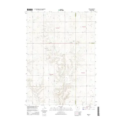
2015 Map of Irene
USGS Topo · Published 2015About this map
Irene sits at a three-county junction in southeastern South Dakota, serving as the primary hub for the surrounding agricultural prairie. This 2015 survey captures a landscape precisely organized by the Public Land Survey System, where a rigid grid of roads like 452nd Ave and 297th St dictates the flow of travel between farmsteads. The town itself is centered on E Main St, with the local cemetery, Hillcrest Cem, positioned just to the west. Outside the town limits, the terrain is defined by subtle drainage patterns, most notably Turkey Cr and Smoky Run, which carve winding paths through the rectangular sections. Genealogists will find the distribution of burial grounds particularly significant, with Salem Cem and Pioneer Cem located a short distance from the settlement, marking the established heritage of this rural community.
Find a feature on this map
30 named features on this map. Tap any name to fly to it.
Don’t see what you’re looking for? This feature index may not catch every label — zoom into the map to look around manually.
Map Details
Editions of this 2015 Irene Map
This is the sole edition of this map. No revisions or reprints were ever made.
Other maps of this area

1898 · Parker
USGS Topo · 1:125,000

1955 · Sioux City
USGS Topo · 1:250,000

1955 · Sioux Falls
USGS Topo · 1:250,000

1957 · Gayville
USGS Topo · 1:24,000

1957 · Mayfield
USGS Topo · 1:24,000

1957 · Mission Hill
USGS Topo · 1:24,000

1958 · Sioux City
USGS Topo · 1:250,000

1958 · Sioux Falls
USGS Topo · 1:250,000

1959 · Sioux City
USGS Topo · 1:250,000
1968 · Wakonda
USGS Topo · 1:24,000