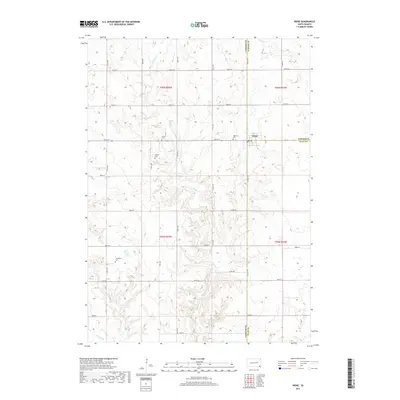
2017 Map of Irene
USGS Topo · Published 2017About this map
Irene sits at a unique geographic crossroads where the boundaries of Yankton, Turner, and Clay Counties converge. This 2017 survey shows a community defined by its agricultural grid, where roads like 297th St and Co Hwy 29 connect the town to the surrounding countryside. The landscape is characterized by its drainage patterns, most notably Turkey Cr and Smoky Run, which carve through the sectional farmland. For genealogists and local historians, the map is particularly valuable for its documentation of several rural burial grounds. Four distinct cemeteries—Salem Cem, Pioneer Cem, Hillcrest Cem, and Trondhjem Cem—are clearly marked, preserving the location of early pioneer and church-affiliated sites. The map illustrates a modern rural South Dakota landscape that remains deeply tied to its historical section lines and small-town center.
Find a feature on this map
27 named features on this map. Tap any name to fly to it.
Don’t see what you’re looking for? This feature index may not catch every label — zoom into the map to look around manually.
Map Details
Editions of this 2017 Irene Map
This is the sole edition of this map. No revisions or reprints were ever made.
Other maps of this area

1898 · Parker
USGS Topo · 1:125,000

1955 · Sioux City
USGS Topo · 1:250,000

1955 · Sioux Falls
USGS Topo · 1:250,000

1957 · Gayville
USGS Topo · 1:24,000

1957 · Mayfield
USGS Topo · 1:24,000

1957 · Mission Hill
USGS Topo · 1:24,000

1958 · Sioux City
USGS Topo · 1:250,000

1958 · Sioux Falls
USGS Topo · 1:250,000

1959 · Sioux City
USGS Topo · 1:250,000
1968 · Wakonda
USGS Topo · 1:24,000