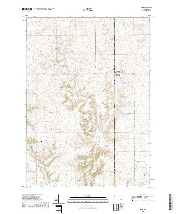
2021 Map of Irene
USGS Topo · Published 2021About this map
Irene sits at the intersection of three counties, serving as a hub for the surrounding agricultural plains in this southeastern South Dakota landscape. The town is flanked by a significant concentration of rural cemeteries, including Salem Cem, Hillcrest Cem, and the Trondhjem Cem further south. These sites, along with the Pioneer Cem near the center of the survey, provide critical anchor points for genealogists and local historians tracking early settlement families. The terrain is defined by the winding course of Turkey Cr, which meanders through the township grids of T96N and T95N, while Smoky Run touches the southwestern corner. The map reveals a highly structured section-line road system, with routes like Co HWY 29 and 297th St providing the primary framework for this productive farming region.
Find a feature on this map
32 named features on this map. Tap any name to fly to it.
Don’t see what you’re looking for? This feature index may not catch every label — zoom into the map to look around manually.
Map Details
Editions of this 2021 Irene Map
This is the sole edition of this map. No revisions or reprints were ever made.
Other maps of this area

1898 · Parker
USGS Topo · 1:125,000

1955 · Sioux City
USGS Topo · 1:250,000

1955 · Sioux Falls
USGS Topo · 1:250,000

1957 · Gayville
USGS Topo · 1:24,000

1957 · Mayfield
USGS Topo · 1:24,000

1957 · Mission Hill
USGS Topo · 1:24,000

1958 · Sioux City
USGS Topo · 1:250,000

1958 · Sioux Falls
USGS Topo · 1:250,000

1959 · Sioux City
USGS Topo · 1:250,000
1968 · Wakonda
USGS Topo · 1:24,000