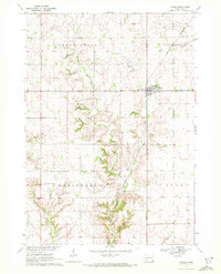
1970 Map of Irene
USGS Topo · Published 1972About this map
Irene sits at the junction of Turner, Yankton, and Clay counties, serving as a focal point for the surrounding agricultural townships of Daneville, Marindahl, and Star. The town's layout is marked by its central Park and a Water Tank, while the Burlington Northern railroad line cuts through the landscape, linking the community to broader trade networks. This 1970 field-checked survey highlights a deeply established rural social fabric, evidenced by numerous historical burial grounds such as Salem Cem, Pioneer Cem, and Hillcrest Cem, alongside the Trondhjem Ch.
Find a feature on this map
21 named features on this map. Tap any name to fly to it.
Don’t see what you’re looking for? This feature index may not catch every label — zoom into the map to look around manually.
Map Details
Editions of this 1970 Irene Map
This is the sole edition of this map. No revisions or reprints were ever made.
Other maps of this area

1898 · Parker
USGS Topo · 1:125,000

1955 · Sioux City
USGS Topo · 1:250,000

1955 · Sioux Falls
USGS Topo · 1:250,000

1957 · Gayville
USGS Topo · 1:24,000

1957 · Mayfield
USGS Topo · 1:24,000

1957 · Mission Hill
USGS Topo · 1:24,000

1958 · Sioux City
USGS Topo · 1:250,000

1958 · Sioux Falls
USGS Topo · 1:250,000

1959 · Sioux City
USGS Topo · 1:250,000
1968 · Wakonda
USGS Topo · 1:24,000