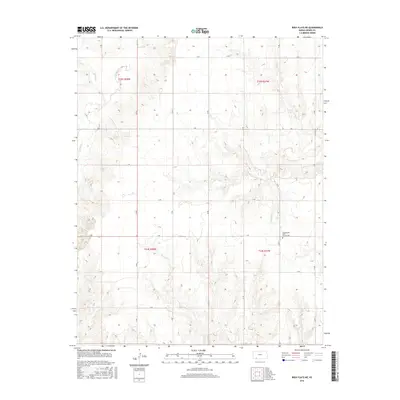
2016 Map of Irish Flats NE
USGS Topo · Published 2016About this map
Countryside Bible Church Cem serves as a primary landmark in this rural landscape of Meade County, established within the High Plains terrain. The area is defined by a distinct drainage pattern where Crooked Cr and its tributaries, including Spring Cr, Sand Cr, and Remuda Cr, carve through the topography. The map reveals a strictly organized section-line road system, including routes like 18 RD and V RD, which dictate the movement of local transit and agricultural transport across the township boundaries of t32s r27w and t33s r27w. This network of local connectors highlights the persistent rural character of the region, where water sources and modest religious sites remain the focal points for the surrounding community.
Find a feature on this map
24 named features on this map. Tap any name to fly to it.
Don’t see what you’re looking for? This feature index may not catch every label — zoom into the map to look around manually.
Map Details
Editions of this 2016 Irish Flats NE Map
This is the sole edition of this map. No revisions or reprints were ever made.
Other maps of this area
1892 · Meade
USGS Topo · 1:125,000

1955 · Dodge City
USGS Topo · 1:250,000

1958 · Dodge City
USGS Topo · 1:250,000

1959 · Dodge City
USGS Topo · 1:250,000
1962 · Irish Flats NE
USGS Topo · 1:24,000
1962 · Irish Flats SE
USGS Topo · 1:24,000
1963 · Lake Larrabee
USGS Topo · 1:24,000
1963 · Irish Flats
USGS Topo · 1:24,000
1963 · Meade
USGS Topo · 1:24,000
1963 · Missler
USGS Topo · 1:24,000