
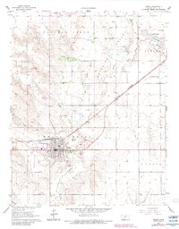
1963 Map of Meade
USGS Topo · Published 1964About this map
The Artesian Valley defines the landscape of this High Plains region, where numerous flowing wells tap into the subsurface water supply north of Meade. This 1960s survey illustrates a rural economy transitioning between traditional agriculture and mid-century industrial utility, evidenced by the presence of the Cudahey Mine and the active tracks of the Chicago Rock Island and Pacific railroad. The town of Meade itself serves as a clear center of gravity for the area, featuring a grid of residential streets, the County Fairground, and a Drive-in Theater on its western edge.
Find a feature on this map
23 named features on this map. Tap any name to fly to it.
Don’t see what you’re looking for? This feature index may not catch every label — zoom into the map to look around manually.
Map Details
Editions of this 1963 Meade Map
2 editions found
Other maps of this area

1892 · Meade
USGS Topo · 1:125,000

1955 · Dodge City
USGS Topo · 1:250,000

1958 · Dodge City
USGS Topo · 1:250,000

1959 · Dodge City
USGS Topo · 1:250,000

1962 · Irish Flats NE
USGS Topo · 1:24,000

1963 · Lake Larrabee
USGS Topo · 1:24,000

1963 · Missler
USGS Topo · 1:24,000

1967 · Fowler SW
USGS Topo · 1:24,000
1968 · Meade NW
USGS Topo · 1:24,000

1969 · Meade NE
USGS Topo · 1:24,000