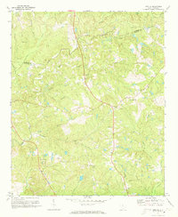
1971 Map of Irmo NE
USGS Topo · Published 1973About this map
Cedar Creek and its many tributaries, including Persimmon Fork and Horse Creek, carve through the rural countryside along the boundary of Fairfield Co and Richland Co. The landscape in the early 1970s is defined by a dense network of country churches and family burial grounds, reflecting the deep-rooted community history of this South Carolina interior. Notable spiritual and social landmarks include Beulah Ch, St Marks Ch, and Taylor Chapel, many of which are accompanied by their own dedicated cemeteries such as St Marks Cem. This era shows a transition toward modern infrastructure with a prominent telephone pipeline and an electrical Substation appearing alongside established landmarks like the Gaging Sta on Williams Branch. The map preserves the placement of small rural outposts like Camp Dixon and recreational developments such as a local Golf Course near Messiah Cem.
Find a feature on this map
43 named features on this map. Tap any name to fly to it.
Don’t see what you’re looking for? This feature index may not catch every label — zoom into the map to look around manually.
Map Details
Editions of this 1971 Irmo NE Map
3 editions found
Other maps of this area

1904 · Columbia
USGS Topo · 1:125,000

1935 · Killian
USGS Topo · 1:48,000

1937 · Killian
USGS Topo · 1:62,500

1941 · Spartanburg
USGS Topo · 1:250,000

1942 · Camden
USGS Topo · 1:125,000

1946 · Irmo
USGS Topo · 1:24,000

1947 · Columbia North
USGS Topo · 1:24,000

1947 · Richtex
USGS Topo · 1:24,000

1948 · Irmo
USGS Topo · 1:24,000

1948 · Columbia North
USGS Topo · 1:24,000