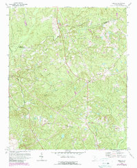
1971 Map of Irmo NE
USGS Topo · Published 1990About this map
Richland County's interior uplands north of Columbia are defined here by a dense network of streams and rural community landmarks. Significant water bodies such as Big Cedar Creek and Crane Creek carve through the landscape, dictating the placement of early road networks and family-named cemeteries. For those researching local lineages, the map identifies several distinct burial sites and places of worship, including Shiloh Cem, Warick Cem, and Messiah Cem. The transition from the rural character of the 1940s to the developments of the early 1970s is evident in the inclusion of modern infrastructure like a Substation and a Golf Course, while the Fairfield County and Richland County boundary line traces the northern portion of the sheet. The prevalence of small church congregations, such as Mt Zion Ch and Beulah Ch, highlights the decentralized nature of these historical communities during this era of South Carolina history.
Find a feature on this map
35 named features on this map. Tap any name to fly to it.
Don’t see what you’re looking for? This feature index may not catch every label — zoom into the map to look around manually.
Map Details
Editions of this 1971 Irmo NE Map
3 editions found
Other maps of this area

1904 · Columbia
USGS Topo · 1:125,000

1935 · Killian
USGS Topo · 1:48,000

1937 · Killian
USGS Topo · 1:62,500

1941 · Spartanburg
USGS Topo · 1:250,000

1942 · Camden
USGS Topo · 1:125,000

1946 · Irmo
USGS Topo · 1:24,000

1947 · Columbia North
USGS Topo · 1:24,000

1947 · Richtex
USGS Topo · 1:24,000

1948 · Irmo
USGS Topo · 1:24,000

1948 · Columbia North
USGS Topo · 1:24,000