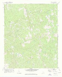
1971 Map of Irmo NE
USGS Topo · Published 1973About this map
Cedar Creek and its many tributaries, including Chappel Branch and Williams Branch, dominate this Richland and Fairfield County landscape during the early 1970s. The area maintains a rural character defined by a dense network of country houses of worship and family-named cemeteries. Notable spiritual centers include Beulah Ch, St Andrews Ch, and Taylor Chapel Ch, often situated near their respective burial grounds. Evidence of recreational and community development appears in the south with the Golf Course and Camp Dixon near Beasley Cr. The Sou railroad corridor provides a clear industrial contrast to the winding creek beds and wooded terrain, while a Gaging Sta on Cedar Creek indicates ongoing water resource management in this South Carolina Piedmont region. The map captures a moment of transition where traditional rural structures remain prominent alongside modern utility infrastructure like the Substation.
Find a feature on this map
39 named features on this map. Tap any name to fly to it.
Don’t see what you’re looking for? This feature index may not catch every label — zoom into the map to look around manually.
Map Details
Editions of this 1971 Irmo NE Map
3 editions found
Other maps of this area

1904 · Columbia
USGS Topo · 1:125,000

1935 · Killian
USGS Topo · 1:48,000

1937 · Killian
USGS Topo · 1:62,500

1941 · Spartanburg
USGS Topo · 1:250,000

1942 · Camden
USGS Topo · 1:125,000

1946 · Irmo
USGS Topo · 1:24,000

1947 · Columbia North
USGS Topo · 1:24,000

1947 · Richtex
USGS Topo · 1:24,000

1948 · Irmo
USGS Topo · 1:24,000

1948 · Columbia North
USGS Topo · 1:24,000