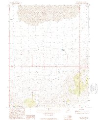
1989 Map of Iron Mine Pass
USGS Topo · Published 1989About this map
Sevier Lake dominates the northern landscape of this Great Basin terrain, where the arid basin floor meets the rising slopes of the San Francisco Mountains. The map reveals a history of resource extraction concentrated near Iron Mine Pass, where evidence of exploration is preserved through labels for multiple Mine Shafts, Adits, and a Prospect. These features indicate a period of intense mineral interest in the southern reaches of the quadrangle, contrasted by the specialized agricultural infrastructure found elsewhere, such as the School Bus Corral and several isolated water management features like Lakeview Reservoir. The network of unimproved roads and trails suggests a landscape primarily utilized for ranching and mining during the late 20th century.
Find a feature on this map
14 named features on this map. Tap any name to fly to it.
Don’t see what you’re looking for? This feature index may not catch every label — zoom into the map to look around manually.
Map Details
Editions of this 1989 Iron Mine Pass Map
This is the sole edition of this map. No revisions or reprints were ever made.
Other maps of this area

1953 · Richfield
USGS Topo · 1:250,000

1958 · Richfield
USGS Topo · 1:250,000

1960 · Frisco Peak
USGS Topo · 1:62,500

1960 · Beaver Lake Mts.
USGS Topo · 1:62,500

1960 · The Barn
USGS Topo · 1:62,500

1972 · Headlight Mtn
USGS Topo · 1:24,000
1972 · Sevier Lake SW
USGS Topo · 1:24,000

1980 · Wah Wah Mts. North
USGS Topo · 1:100,000
1989 · High Rock
USGS Topo · 1:24,000
1989 · Frisco Peak
USGS Topo · 1:24,000