
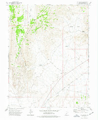
1972 Map of Headlight Mtn
USGS Topo · Published 1974About this map
The Cricket Mountains dominate this high-desert landscape in Millard County, rising sharply above the eastern shore of Sevier Lake. The terrain is characterized by a series of north-south running ridges and valleys, including Cedar Valley and Red Valley, which are punctuated by distinctive landmarks such as Petes Knoll and Monument Point. This 1970s survey illustrates a specialized local geography of named passes and gaps, including Headlight Gap, Cys Pass, and Lone Cedar Pass, which facilitate movement through the steep range. Evidence of land use is limited to a few features like Cricket Reservoir, a lonely Storage Bin, and a Jeep Trail, suggesting an area primarily used for grazing or mineral exploration, further hinted at by Mine Canyon in the northern reaches of the quadrangle.
Find a feature on this map
23 named features on this map. Tap any name to fly to it.
Don’t see what you’re looking for? This feature index may not catch every label — zoom into the map to look around manually.
Map Details
Editions of this 1972 Headlight Mtn Map
This is the sole edition of this map. No revisions or reprints were ever made.
Other maps of this area

1885 · Beaver
USGS Topo · 1:250,000

1953 · Richfield
USGS Topo · 1:250,000

1958 · Richfield
USGS Topo · 1:250,000

1960 · Beaver Lake Mts.
USGS Topo · 1:62,500
1972 · Needle Point
USGS Topo · 1:24,000
1972 · Sevier Lake NE
USGS Topo · 1:24,000
1972 · Sevier Lake SW
USGS Topo · 1:24,000

1973 · Black Rock
USGS Topo · 1:24,000
1973 · Candland Spring
USGS Topo · 1:24,000
1973 · Cat Canyon
USGS Topo · 1:24,000