
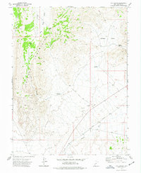
1973 Map of Black Rock
USGS Topo · Published 1976About this map
Beaver River and the Union Pacific railroad corridor define this arid Millard County landscape in the early 1970s. The settlement of Black Rock serves as a primary point of reference, situated near the Black Rock Well and several vital water sources including Kaufman Seep, Big Spring, and the uniquely named Tie House Spring. The terrain transitions from the river valley to the expansive Shifting Sand formations in the southwest, illustrating the challenging environment faced by those managing livestock or working the rail line.
Find a feature on this map
18 named features on this map. Tap any name to fly to it.
Don’t see what you’re looking for? This feature index may not catch every label — zoom into the map to look around manually.
Map Details
Editions of this 1973 Black Rock Map
This is the sole edition of this map. No revisions or reprints were ever made.
Other maps of this area

1885 · Beaver
USGS Topo · 1:250,000

1953 · Richfield
USGS Topo · 1:250,000

1958 · Richfield
USGS Topo · 1:250,000

1960 · Beaver Lake Mts.
USGS Topo · 1:62,500

1972 · Headlight Mtn
USGS Topo · 1:24,000

1973 · Cruz
USGS Topo · 1:24,000

1973 · Pinnacle Pass
USGS Topo · 1:24,000

1973 · Antelope Spring
USGS Topo · 1:24,000

1973 · Read
USGS Topo · 1:24,000
1973 · Cat Canyon
USGS Topo · 1:24,000