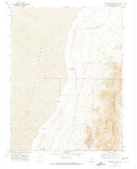
1972 Map of Sevier Lake NE
USGS Topo · Published 1974About this map
Sevier Lake dominates the western half of this 1970s landscape, where its arid shoreline meets the rising elevation of the Cricket Mountains. The map reveals a sophisticated water management system for such a parched environment, documented through the placement of the Fillmore Wash Reservoir, Coates Reservoir, and Nelson Reservoir No 2. These catchment points were essential for supporting the region's sparse resource-based activity, evidenced by the presence of scattered prospects and a single mine road located in the southern reaches of the mountains.
Find a feature on this map
13 named features on this map. Tap any name to fly to it.
Don’t see what you’re looking for? This feature index may not catch every label — zoom into the map to look around manually.
Map Details
Editions of this 1972 Sevier Lake NE Map
This is the sole edition of this map. No revisions or reprints were ever made.
Other maps of this area

1885 · Beaver
USGS Topo · 1:250,000

1885 · Sevier Desert
USGS Topo · 1:250,000

1908 · Fish Springs
USGS Topo · 1:250,000

1910 · Fish Springs
USGS Topo · 1:250,000

1953 · Richfield
USGS Topo · 1:250,000

1953 · Delta
USGS Topo · 1:250,000

1958 · Richfield
USGS Topo · 1:250,000

1958 · Delta
USGS Topo · 1:250,000

1962 · Delta
USGS Topo · 1:250,000

1971 · Red Pass
USGS Topo · 1:24,000