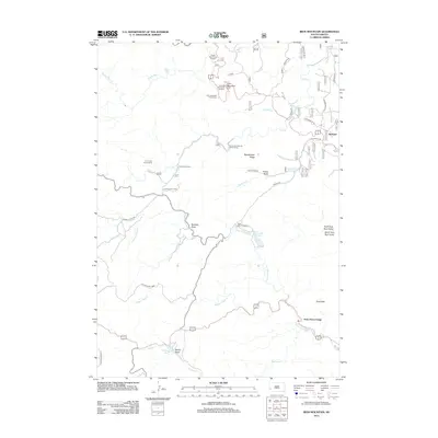
2012 Map of Iron Mountain
USGS Topo · Published 2012About this map
State Game Lodge and the surrounding wilderness of Custer State Park define this landscape, where early 21st-century conservation and recreation converge. The area is marked by significant cultural landmarks including the Black Hills Playhouse and the Norbeck Memorial Overlook, providing a view of the high-elevation terrain around Iron Mountain. The settlement pattern is largely seasonal and recreational, featuring the Iron Creek Summer Home Group, Camp Remington, and the Iron Creek Horse Camp. Water features are abundant, from the cascade at Grizzly Bear Falls to the calm reaches of Legion Lake and Center Lake. In the northeastern corner, the small community of Spokane sits near the winding paths of S Playhouse Rd and Spokane Rd, tracing the legacy of earlier development in the Black Hills.
Find a feature on this map
39 named features on this map. Tap any name to fly to it.
Don’t see what you’re looking for? This feature index may not catch every label — zoom into the map to look around manually.
Map Details
Editions of this 2012 Iron Mountain Map
This is the sole edition of this map. No revisions or reprints were ever made.
Other maps of this area

1894 · Hermosa
USGS Topo · 1:125,000

1896 · Harney Peak
USGS Topo · 1:125,000

1901 · Hermosa
USGS Topo · 1:125,000

1901 · Harney Peak
USGS Topo · 1:125,000
1954 · Rockerville
USGS Topo · 1:24,000

1954 · Iron Mountain
USGS Topo · 1:24,000
1954 · Mount Rushmore
USGS Topo · 1:24,000

1954 · Custer
USGS Topo · 1:24,000

1954 · Hill City
USGS Topo · 1:24,000

1954 · Hayward
USGS Topo · 1:24,000