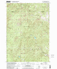
1998 Map of Iron Mountain
USGS Topo · Published 2001About this map
Mount Rushmore National Memorial anchors the northern boundary of this survey, which captures the rugged transition into the Black Hills National Forest and Custer State Park. The terrain is characterized by a dense network of gulches and draws, such as Potato Gulch and Norbeck Draw, which dictate the placement of local settlements and infrastructure. Institutional footprints are visible at the Black Hills Playhouse and the Custer State Park Headquarters, while the State Park Sch provides evidence of the established community within the park boundaries.
Find a feature on this map
34 named features on this map. Tap any name to fly to it.
Don’t see what you’re looking for? This feature index may not catch every label — zoom into the map to look around manually.
Map Details
Editions of this 1998 Iron Mountain Map
This is the sole edition of this map. No revisions or reprints were ever made.
Other maps of this area

1894 · Hermosa
USGS Topo · 1:125,000

1896 · Harney Peak
USGS Topo · 1:125,000

1901 · Hermosa
USGS Topo · 1:125,000

1901 · Harney Peak
USGS Topo · 1:125,000
1954 · Rockerville
USGS Topo · 1:24,000

1954 · Iron Mountain
USGS Topo · 1:24,000
1954 · Mount Rushmore
USGS Topo · 1:24,000

1954 · Custer
USGS Topo · 1:24,000

1954 · Hill City
USGS Topo · 1:24,000

1954 · Hayward
USGS Topo · 1:24,000