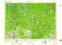
1959 Map of Iron Mountain
USGS Topo · Published 1959About this map
The Wisconsin River and its numerous tributaries define this 1950s landscape of the Upper Midwest, where timber and tourism were the primary drivers of settlement. This area is characterized by immense water systems, including the Rainbow Flowage and Spirit River Flowage, alongside the vast timberlands of the Nicolet National Forest. Major population centers like Rhinelander and Antigo serve as hubs for the region, connected by a network of heavy duty roads and multiple rail lines, such as the Chicago and North Western Ry. The map clearly delineates various indigenous lands, including the Lac du Flambeau Indian Reservation and Mole Lake Indian Reservation. To the northeast, the border town of Iron Mountain marks the transition into Michigan, highlighting the cross-state industrial and geographic ties of the Iron Range and the Menominee River.
Find a feature on this map
109 named features on this map. Tap any name to fly to it.
Don’t see what you’re looking for? This feature index may not catch every label — zoom into the map to look around manually.
Map Details
Editions of this 1959 Iron Mountain Map
2 editions found

Other maps of this area

1898 · Iron River
USGS Topo · 1:62,500

1899 · Sagola
USGS Topo · 1:62,500

1899 · Crystal Falls
USGS Topo · 1:62,500

1899 · Wausau
USGS Topo · 1:125,000

1902 · Wausau
USGS Topo · 1:125,000

1902 · Marathon
USGS Topo · 1:125,000

1928 · Three Lakes
USGS Topo · 1:48,000

1930 · Robbins
USGS Topo · 1:48,000

1938 · Phelps
USGS Topo · 1:48,000

1938 · Minocqua
USGS Topo · 1:48,000