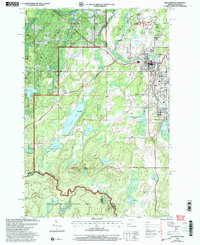
1999 Map of Iron River
USGS Topo · Published 2004About this map
Homer Location and Forbes Location stand as distinct residential settlements within this Upper Peninsula landscape, reflecting the local history of mining and industry near the Michigan-Wisconsin border. Situated in Iron County, these small communities represent the specialized housing clusters typically established by mining companies for their workforce. The map highlights the settlement patterns that evolved around the region's natural resources, showing the relationship between concentrated residential areas and the surrounding timberlands. While the primary urban centers lay just outside these specific sites, the detailed layout of Forbes Location provides researchers and genealogists with a precise view of these historic locations during a period of modern revision based on older topographical foundations.
Find a feature on this map
2 named features on this map. Tap any name to fly to it.
Don’t see what you’re looking for? This feature index may not catch every label — zoom into the map to look around manually.
Map Details
Editions of this 1999 Iron River Map
This is the sole edition of this map. No revisions or reprints were ever made.
Other maps of this area

1898 · Iron River
USGS Topo · 1:62,500

1938 · Alvin
USGS Topo · 1:48,000

1939 · Long Lake
USGS Topo · 1:48,000

1944 · Iron River
USGS Topo · 1:24,000

1944 · Gaastra
USGS Topo · 1:24,000

1945 · Gibbs City
USGS Topo · 1:24,000

1945 · Sunset Lake
USGS Topo · 1:24,000

1946 · Iron River
USGS Topo · 1:31,680

1946 · Sunset Lake
USGS Topo · 1:31,680

1946 · Gaastra
USGS Topo · 1:31,680