
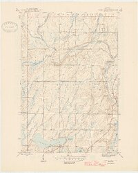
1946 Map of Sunset Lake
USGS Topo · Published 1946About this map
Sunset Lake and its surrounding wetlands anchor this mid-1940s survey of Iron County. The landscape is defined by a dense network of watercourses, including the Net River and the Paint River, which converge in a region shaped by timber and water power. A notable industrial marker is the Paint Dam (Abandoned) on the northern reach of the Paint River, signifying a shift in local water management. Near the confluence of the river and Parks Creek, the Me-Squak-Cum-E Park occupies the riverbank, while the waterway itself transitions through Hemlock Rapids and Lower Hemlock Rapids. Numerous numbered lakes, such as Lake Sixteen, Lake Nine, and Lake Fifteen, dot the southern terrain, linked by small tributaries like Costigan Creek and Crystal Spring Creek. The map reflects an era when the interior of the Upper Peninsula was heavily utilized for its natural resources, with the infrastructure of dams and parks still clearly delineated.
Find a feature on this map
22 named features on this map. Tap any name to fly to it.
Don’t see what you’re looking for? This feature index may not catch every label — zoom into the map to look around manually.
Map Details
Editions of this 1946 Sunset Lake Map
2 editions found
Other maps of this area

1895 · Ned Lake
USGS Topo · 1:62,500

1895 · Perch Lake
USGS Topo · 1:62,500

1898 · Iron River
USGS Topo · 1:62,500

1899 · Crystal Falls
USGS Topo · 1:62,500

1944 · Iron River
USGS Topo · 1:24,000

1944 · Gaastra
USGS Topo · 1:24,000

1944 · Fortune Lakes
USGS Topo · 1:24,000

1945 · Gibbs City
USGS Topo · 1:24,000

1945 · Sunset Lake
USGS Topo · 1:24,000

1945 · Amasa
USGS Topo · 1:24,000