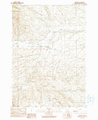
1990 Map of Ironside
USGS Topo · Published 1990About this map
Ironside serves as the central hub of this Eastern Oregon landscape, situated at a junction of creek valleys and historical lines. A significant historical marker, the Old Indian Treaty Boundary, bisects the terrain, illustrating the formal division of lands in Malheur County. The hydrology of the area is defined by a network of drainage systems including Willows Creek, Boulder Creek, and Middle Willow Creek, which carve through the high-elevation terrain. Land use in this arid environment is highlighted by features such as the Rock Quarry Reservoir and Mud Flat Spring, suggesting the vital importance of water management and resource extraction to the local economy. The geography is further detailed by numerous named gulches and valleys, such as Sand Gulch and Lost Valley, reflecting a territory where topographic relief and seasonal water flow dictate the pattern of settlement and movement.
Find a feature on this map
22 named features on this map. Tap any name to fly to it.
Don’t see what you’re looking for? This feature index may not catch every label — zoom into the map to look around manually.
Map Details
Editions of this 1990 Ironside Map
This is the sole edition of this map. No revisions or reprints were ever made.
Other maps of this area

1908 · Ironside Mountain
USGS Topo · 1:125,000

1955 · Baker
USGS Topo · 1:250,000

1955 · Canyon City
USGS Topo · 1:250,000

1959 · Baker
USGS Topo · 1:250,000

1959 · Canyon City
USGS Topo · 1:250,000

1964 · Ironside
USGS Topo · 1:62,500

1966 · Clover Creek Ranch
USGS Topo · 1:62,500

1970 · Castle Rock
USGS Topo · 1:62,500
1972 · Hereford
USGS Topo · 1:24,000
1972 · Eldorado Pass
USGS Topo · 1:24,000