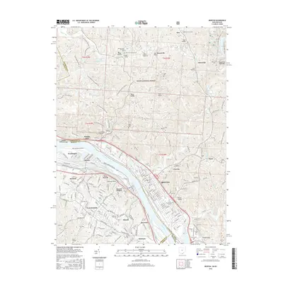
2016 Map of Ironton
USGS Topo · Published 2016About this map
Ironton and its Kentucky neighbors across the Ohio River appear here in a landscape shaped by early industrial legacies and modern civic growth. The northern portion of the map is dominated by the Wayne National Forest, where remnants of the region's iron history are visible at Vesuvius Furnace and the Etna Furnace Cem. These hills are crisscrossed by specialized routes like the Hanging Rock Loop OHV, while the southern reaches show the dense urban footprints of Russell, Flatwoods, and Raceland. The river serves as a corridor for infrastructure, from the Ashland Regional Airport to the CSX rail lines. Family history is deeply rooted across the terrain, evidenced by numerous burial sites like Woodland Cem, Saint Marys Catholic Cem, and the Hecla Cem near the community of Hecla.
Find a feature on this map
101 named features on this map. Tap any name to fly to it.
Don’t see what you’re looking for? This feature index may not catch every label — zoom into the map to look around manually.
Map Details
Editions of this 2016 Ironton Map
This is the sole edition of this map. No revisions or reprints were ever made.
Other maps of this area

1898 · Ironton
USGS Topo · 1:62,500

1900 · Ironton
USGS Topo · 1:62,500

1901 · Ceredo
USGS Topo · 1:62,500

1903 · Kenova
USGS Topo · 1:125,000

1904 · Kenova
USGS Topo · 1:125,000

1913 · Ceredo
USGS Topo · 1:62,500

1926 · Greenup
USGS Topo · 1:48,000

1930 · Greenup
USGS Topo · 1:62,500
1953 · Ashland
USGS Topo · 1:24,000

1953 · Greenup
USGS Topo · 1:24,000