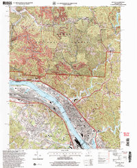
2002 Map of Ironton
USGS Topo · Published 2006About this map
The Ohio River corridor serves as the industrial and transit backbone for this region, anchoring the riverfront cities of Ironton, Russell, and Coal Grove. This 2002 revision captures a landscape defined by the convergence of heavy rail lines like the Chesapeake and Ohio RR and the Norfolk and Western RR with historical extraction sites. To the north, the wooded reaches of the Wayne National Forest reveal a different era of industry, most notably at the Vesuvius Furnace (Ruins) near Lake Vesuvius.
Find a feature on this map
84 named features on this map. Tap any name to fly to it.
Don’t see what you’re looking for? This feature index may not catch every label — zoom into the map to look around manually.
Map Details
Editions of this 2002 Ironton Map
This is the sole edition of this map. No revisions or reprints were ever made.
Other maps of this area

1898 · Ironton
USGS Topo · 1:62,500

1900 · Ironton
USGS Topo · 1:62,500

1901 · Ceredo
USGS Topo · 1:62,500

1903 · Kenova
USGS Topo · 1:125,000

1904 · Kenova
USGS Topo · 1:125,000

1913 · Ceredo
USGS Topo · 1:62,500

1926 · Greenup
USGS Topo · 1:48,000

1930 · Greenup
USGS Topo · 1:62,500
1953 · Ashland
USGS Topo · 1:24,000

1953 · Greenup
USGS Topo · 1:24,000