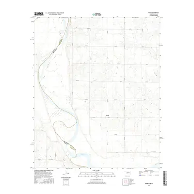
2016 Map of Irving
USGS Topo · Published 2016About this map
Red River meanders along the border between Oklahoma and Texas, defining the southwestern edge of this survey in Jefferson County. The small settlement of Irving sits atop the higher ground east of the river's floodplains, surrounded by a grid of rural section-line roads such as Ew 18 and NS 6. The landscape transitions from the river's wide, alluvial bottomlands to the terraced terrain where family-named landmarks like Noble Wray Rd, F Schaffner Rd, and Burrus Rd indicate long-standing local agricultural properties. This 2016 record shows the intricate network of secondary routes and country lanes that connect these isolated homesteads to larger thoroughfares like FM 171, providing a clear view of the region's modern rural geography and transportation patterns.
Find a feature on this map
34 named features on this map. Tap any name to fly to it.
Don’t see what you’re looking for? This feature index may not catch every label — zoom into the map to look around manually.
Map Details
Editions of this 2016 Irving Map
This is the sole edition of this map. No revisions or reprints were ever made.
Other maps of this area
1901 · Addington
USGS Topo · 1:125,000
1905 · Montague
USGS Topo · 1:125,000
1954 · Sherman
USGS Topo · 1:250,000
1954 · Wichita Falls
USGS Topo · 1:250,000
1955 · Lawton
USGS Topo · 1:250,000
1956 · Henrietta
USGS Topo · 1:62,500
1957 · Hastings
USGS Topo · 1:62,500
1957 · Ardmore
USGS Topo · 1:250,000
1958 · Wichita Falls
USGS Topo · 1:250,000
1958 · Sherman
USGS Topo · 1:250,000