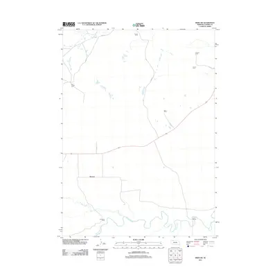
2011 Map of Irwin SW
USGS Topo · Published 2011About this map
The Niobrara River and its meandering path define the southern landscape of this Cherry County region, where the small community of Bayonne sits centrally among a network of established family ranches. This early 21st-century documentation illustrates a rural ranching economy tied closely to the land and water, with family holdings such as the Emil Fuchser Ranch and Bornemann Ranch distributed across the northern and southern plains. North of the river, Hay Creek winds through the terrain, while infrastructure remains sparse, consisting primarily of gravel and dirt routes like Irwin Rd and Trail Rd. A notable crossing point is found at Lions Bridge in the southeastern corner, serving as a vital link across the Niobrara. The map provides a clear picture of the vast, open-space land management typical of the Nebraska Sandhills, preserved through generations of family ranching including the Harmon Ranch and Shadbolt Ranch.
Find a feature on this map
12 named features on this map. Tap any name to fly to it.
Don’t see what you’re looking for? This feature index may not catch every label — zoom into the map to look around manually.
Map Details
Editions of this 2011 Irwin SW Map
This is the sole edition of this map. No revisions or reprints were ever made.
Other maps of this area

1950 · Irwin
USGS Topo · 1:62,500

1951 · Irwin
USGS Topo · 1:62,500

1951 · Gypsy Valley
USGS Topo · 1:62,500

1955 · Alliance
USGS Topo · 1:250,000

1957 · Alliance
USGS Topo · 1:250,000

1957 · Valentine
USGS Topo · 1:250,000

1958 · Alliance
USGS Topo · 1:250,000

1959 · Valentine
USGS Topo · 1:250,000
1969 · Gordon SE
USGS Topo · 1:24,000
1969 · Rushville 4 NE
USGS Topo · 1:24,000