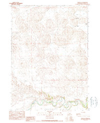
1990 Map of Irwin SW
USGS Topo · Published 1990About this map
The Niobrara River winds across the southern reaches of this landscape, its path defining the northern edge of the Lavaca Flats. This 1990 survey captures a region of Nebraska characterized by isolated ranching operations and the remnants of rural education hubs. The presence of School No 78 in the north and School No 41 in the east suggests a distributed settlement pattern where these small schoolhouses once served as vital community anchors for distant homesteads.
Find a feature on this map
18 named features on this map. Tap any name to fly to it.
Don’t see what you’re looking for? This feature index may not catch every label — zoom into the map to look around manually.
Map Details
Editions of this 1990 Irwin SW Map
This is the sole edition of this map. No revisions or reprints were ever made.
Other maps of this area

1950 · Irwin
USGS Topo · 1:62,500

1951 · Irwin
USGS Topo · 1:62,500

1951 · Gypsy Valley
USGS Topo · 1:62,500

1955 · Alliance
USGS Topo · 1:250,000

1957 · Alliance
USGS Topo · 1:250,000

1957 · Valentine
USGS Topo · 1:250,000

1958 · Alliance
USGS Topo · 1:250,000

1959 · Valentine
USGS Topo · 1:250,000
1969 · Gordon SE
USGS Topo · 1:24,000
1969 · Rushville 4 NE
USGS Topo · 1:24,000