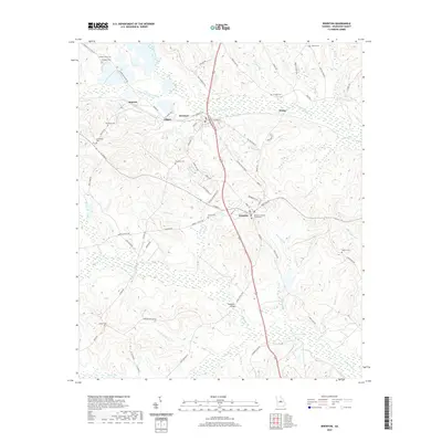
2020 Map of Irwinton
USGS Topo · Published 2020About this map
The Wilkinson County Courthouse serves as the focal point for Irwinton, the historic seat of Wilkinson County, Georgia. This survey documents a landscape defined by the drainage systems of Commissioner Creek and Big Sandy Cr, where numerous smaller tributaries like Town Br and Helton Br carve through the terrain. The settlement pattern follows the established corridors of Gordon-MC Intyre RD and W Main St, connecting the community of Irwinton to neighboring McIntyre and outlying locales such as Edgars and Wriley. Genealogists will find a high density of family-named burial sites, including the Holliman Cem, Brundage Cem, and Shepherd Cem, often located near ancestral roadbeds. Significant local landmarks like Thompson Bridge across the southern wetlands and the rail-oriented industrial character near Dedrich illustrate the county's infrastructure in the modern era.
Find a feature on this map
77 named features on this map. Tap any name to fly to it.
Don’t see what you’re looking for? This feature index may not catch every label — zoom into the map to look around manually.
Map Details
Editions of this 2020 Irwinton Map
This is the sole edition of this map. No revisions or reprints were ever made.
Other maps of this area

1916 · Irwinton
USGS Topo · 1:62,500

1920 · Irwinton
USGS Topo · 1:62,500

1956 · Gordon
USGS Topo · 1:62,500

1956 · Jeffersonville
USGS Topo · 1:62,500

1957 · Macon
USGS Topo · 1:250,000

1958 · Macon
USGS Topo · 1:250,000

1964 · Macon
USGS Topo · 1:250,000
1973 · Gordon
USGS Topo · 1:24,000

1973 · Massey Hill
USGS Topo · 1:24,000
1973 · Napier Pond
USGS Topo · 1:24,000