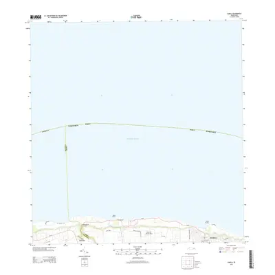
2013 Map of Isabela
USGS Topo · Published 2013About this map
Isabela sits prominently along the northern coast of the Island of Puerto Rico, where the land meets the Atlantic Ocean at several distinct coastal formations. This coastal stretch is defined by prominent points like Punta Sardina and Punta Jacinto, near the geological feature of Foso Jacinto. The map details the residential and urban layout of the early 21st century, showing the expansion of the town and the neighboring community of San Antonio to the west. The landscape transitions from the marine environment to inland drainage patterns, such as the Quebrada de los Cedros. Key local thoroughfares, including Avenida Jobos and Carretera Pozo Dulce, illustrate the modern transportation network connecting these seaside settlements.
Find a feature on this map
22 named features on this map. Tap any name to fly to it.
Don’t see what you’re looking for? This feature index may not catch every label — zoom into the map to look around manually.
Map Details
Editions of this 2013 Isabela Map
This is the sole edition of this map. No revisions or reprints were ever made.
Other maps of this area

1937 · Aguadilla
USGS Topo · 1:20,000

1937 · Moca
USGS Topo · 1:20,000

1938 · Quebradillas
USGS Topo · 1:20,000

1941 · Moca
USGS Topo · 1:30,000

1941 · Isabela
USGS Topo · 1:30,000

1942 · Moca
USGS Topo · 1:30,000

1942 · Aguadilla
USGS Topo · 1:30,000
1950 · Moca NE
USGS Topo · 1:10,000
1950 · Quebradillas NO
USGS Topo · 1:10,000
1950 · Aguadilla NE
USGS Topo · 1:10,000