1950 Map of Quebradillas NO
USGS Topo · Published 1950About this map
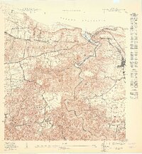
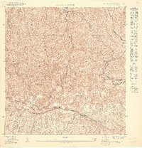
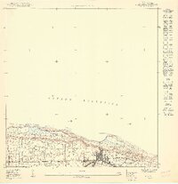
The Río Guajataca carves a deep canyon through this coastal landscape, serving as the natural boundary between the Municipio de Isabela and Municipio de Quebradillas. In the mid-twentieth century, the American Railroad traced the northern coastline, stopping at the Estación Quebradillas to serve the growing municipal seat of Quebradillas. The map reveals a dense network of settlements such as San Antonio and El Centro, interspersed with agricultural barrios like Coco, Guayabos, and Galateo Bajo.
Find a feature on this map
23 named features on this map. Tap any name to fly to it.
Don’t see what you’re looking for? This feature index may not catch every label — zoom into the map to look around manually.
Map Details
Editions of this 1950 Quebradillas NO Map
This is the sole edition of this map. No revisions or reprints were ever made.
Other maps of this area

1937 · Moca
USGS Topo · 1:20,000

1938 · Quebradillas
USGS Topo · 1:20,000

1941 · Moca
USGS Topo · 1:30,000
1941 · Isabela
USGS Topo · 1:30,000

1942 · Moca
USGS Topo · 1:30,000
1950 · Moca SE
USGS Topo · 1:10,000
1950 · Moca NE
USGS Topo · 1:10,000
1950 · Quebradillas SO
USGS Topo · 1:10,000

1950 · Quebradillas SE
USGS Topo · 1:10,000
1950 · Isabela SE
USGS Topo · 1:10,000
Featured Places
- Quebradillas, Quebradillas
- Reparto Apolonio Vélez Ramos, Isabela
- Sector Lasalle, Quebradillas
- Quebradillas
- Coto, Isabela