
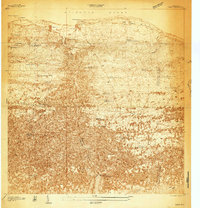
1950 Map of Quebradillas SE
USGS Topo · Published 1950About this map
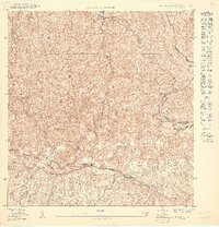
The Lago de Guajataca reservoir dominates the southwestern landscape of this 1950 survey, providing a critical source of water and power for northwestern Puerto Rico. The terrain is defined by the complex topography of the Montañas and the deep gorge cut by the Río Guajataca. Dense networks of small structures and trails suggest a closely-knit rural community where agriculture and local education were central, anchored by institutions like the Escuela Segunda Unidad Baldorioty de Castro.
Find a feature on this map
20 named features on this map. Tap any name to fly to it.
Don’t see what you’re looking for? This feature index may not catch every label — zoom into the map to look around manually.
Map Details
Editions of this 1950 Quebradillas SE Map
This is the sole edition of this map. No revisions or reprints were ever made.
Other maps of this area
1938 · Camuy
USGS Topo · 1:20,000

1938 · San Sebastian
USGS Topo · 1:20,000

1938 · Quebradillas
USGS Topo · 1:20,000

1941 · San Sebastian
USGS Topo · 1:30,000
1942 · Camuy
USGS Topo · 1:30,000

1946 · Bayaney
USGS Topo · 1:30,000
1947 · Bayaney NO
USGS Topo · 1:10,000

1950 · San Sebastian NE
USGS Topo · 1:10,000
1950 · Quebradillas NO
USGS Topo · 1:10,000
1950 · Quebradillas SO
USGS Topo · 1:10,000