
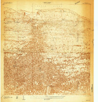
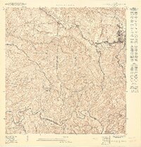
1950 Map of San Sebastian NE
USGS Topo · Published 1950About this map
Lago Guajataca dominates the northern landscape of this mid-century survey, its fingers reaching into the rugged terrain where the borders of Quebradillas, San Sebastián, and Camuy meet. The map documents a rural economy transitioning through the late 1940s, anchored by the Central Soller sugar mill and the nearby settlement of El Pueblito. The intricate contour lines reveal the complex limestone topography of barrios like Aibonito, Hoyamala, and Eneas. Social and religious life is marked by the presence of the Iglesia Santa Ana and Iglesia Santa Teresita, along with the Escuela Centro Filetas. The Río Guajataca carves a deep path southward, joined by tributaries such as Quebrada Varas, illustrating the drainage patterns that defined local land use and transportation during this era of Puerto Rican development.
Find a feature on this map
22 named features on this map. Tap any name to fly to it.
Don’t see what you’re looking for? This feature index may not catch every label — zoom into the map to look around manually.
Map Details
Editions of this 1950 San Sebastian NE Map
This is the sole edition of this map. No revisions or reprints were ever made.
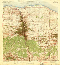
Other maps of this area
1938 · Camuy
USGS Topo · 1:20,000

1938 · San Sebastian
USGS Topo · 1:20,000

1938 · Quebradillas
USGS Topo · 1:20,000

1941 · San Sebastian
USGS Topo · 1:30,000
1942 · Camuy
USGS Topo · 1:30,000

1946 · Bayaney
USGS Topo · 1:30,000
1947 · Bayaney NO
USGS Topo · 1:10,000
1947 · Bayaney SO
USGS Topo · 1:10,000
1950 · San Sebastian SE
USGS Topo · 1:10,000
1950 · Quebradillas SO
USGS Topo · 1:10,000
Featured Places
- Sector Las Lajas, Lares
- Sector El Parque, Lares
- Sector Toño Fuentes, San Sebastián
- Sector Núñez, Lares
- Quebradillas