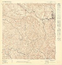
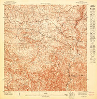
1950 Map of San Sebastian SE
USGS Topo · Published 1950About this map
Lares serves as the focal point for this mountainous landscape at the mid-century, where the dense network of agricultural estates and rural barrios reflects the region's coffee and sugarcane heritage. Named estates such as Hacienda San Pedro and Hacienda Esperanza are tucked into the steep valleys, while the Escuela Narciso Rabell Cabrero provides a clear marker of community infrastructure within the Espino district.
Find a feature on this map
39 named features on this map. Tap any name to fly to it.
Don’t see what you’re looking for? This feature index may not catch every label — zoom into the map to look around manually.
Map Details
Editions of this 1950 San Sebastian SE Map
This is the sole edition of this map. No revisions or reprints were ever made.
Other maps of this area

1938 · San Sebastian
USGS Topo · 1:20,000

1941 · San Sebastian
USGS Topo · 1:30,000

1946 · Maricao
USGS Topo · 1:30,000

1946 · Bayaney
USGS Topo · 1:30,000

1946 · Monte Guilarte
USGS Topo · 1:30,000
1947 · Maricao NO
USGS Topo · 1:10,000
1947 · Maricao NE
USGS Topo · 1:10,000
1947 · Monte Guilarte NO
USGS Topo · 1:10,000
1947 · Bayaney NO
USGS Topo · 1:10,000
1947 · Bayaney SO
USGS Topo · 1:10,000