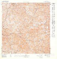
1947 Map of Maricao NO
USGS Topo · Published 1947About this map
The agrarian landscape of western Puerto Rico during the mid-1940s is defined here by the prominent coffee and sugarcane estates that historically shaped the regional economy. Several significant holdings, including Hacienda Constancia, Hacienda Josefa, and Hacienda Teresa, are situated along the winding river valleys. These haciendas represent the traditional settlement patterns of the Cordillera Central, where habitation followed the fertile land near the Rio Bucarabones and Rio Maricao. Community life is anchored by landmarks such as the Iglesia de la Purisima and the Escuela Consolidada Buena Vista. The terrain transitions from the high peaks of Maravilla Este and the Sierra Maravilla down into the barrio of Maricao Afuera, with the municipal boundary of Municipio de Las Marias cutting across the northern elevations.
Find a feature on this map
25 named features on this map. Tap any name to fly to it.
Don’t see what you’re looking for? This feature index may not catch every label — zoom into the map to look around manually.
Map Details
Editions of this 1947 Maricao NO Map
This is the sole edition of this map. No revisions or reprints were ever made.
Other maps of this area

1938 · Alto Sano
USGS Topo · 1:20,000

1938 · San Sebastian
USGS Topo · 1:20,000

1941 · San Sebastian
USGS Topo · 1:30,000

1941 · Rosario
USGS Topo · 1:30,000

1942 · Central La Plata
USGS Topo · 1:30,000

1942 · Rosario
USGS Topo · 1:30,000

1946 · Maricao
USGS Topo · 1:30,000
1946 · Ciales
USGS Topo · 1:30,000
1947 · Maricao NE
USGS Topo · 1:10,000
1947 · Maricao SO
USGS Topo · 1:10,000
Featured Places
- Maravilla Este, Las Marías
- Naranjales, Las Marías
- Palma Escrita, Las Marías
- Buena Vista, Las Marías
- La Josefa, Las Marías