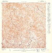
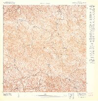
1947 Map of Monte Guilarte NO
USGS Topo · Published 1947About this map
Agricultural haciendas define the landscape of the Cordillera Central in this 1940s topographic study. The terrain is marked by family-run estates and specialized agricultural settlements, including Hacienda Vilella, Hacienda Buena Vista, and Hacienda San Alberto, which follow the deep valleys of Rio Blanco and Rio Guayo. The map reveals the intricate network of footpaths and secondary roads connecting these upland coffee and farming centers at a time when traditional land-use patterns were still dominant.
Find a feature on this map
25 named features on this map. Tap any name to fly to it.
Don’t see what you’re looking for? This feature index may not catch every label — zoom into the map to look around manually.
Map Details
Editions of this 1947 Monte Guilarte NO Map
This is the sole edition of this map. No revisions or reprints were ever made.
Other maps of this area

1938 · San Sebastian
USGS Topo · 1:20,000

1941 · San Sebastian
USGS Topo · 1:30,000

1946 · Maricao
USGS Topo · 1:30,000

1946 · Bayaney
USGS Topo · 1:30,000

1946 · Monte Guilarte
USGS Topo · 1:30,000
1947 · Monte Guilarte NE
USGS Topo · 1:10,000
1947 · Monte Guilarte SO
USGS Topo · 1:10,000
1947 · Maricao NE
USGS Topo · 1:10,000
1947 · Monte Guilarte SE
USGS Topo · 1:10,000
1947 · Maricao SE
USGS Topo · 1:10,000