1950 Map of Quebradillas SO
USGS Topo · Published 1950About this map
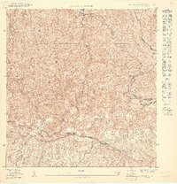
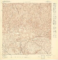
Montañas de Planas dominates this mid-century topographic survey, revealing the complex interior terrain of northwestern Puerto Rico. The landscape is defined by the sharp descent into the Valle de las Quebradas and the winding course of the Río Guajataca as it carves through the limestone karst. Small agricultural clusters like Pueblito de Ponce are situated along the ridgelines, connected by a network of secondary roads and trails that navigate between the steep slopes. High points such as Cerro de la Bandera and Cerro del Judío serve as local landmarks within the barrios of Llanadas, Robles, and Aibonito. This detailed rendering, supervised by Jorge J. Jiménez, captures the rural settlement patterns before modern industrial expansion, documenting the precise municipal boundaries between Isabela and San Sebastián.
Find a feature on this map
14 named features on this map. Tap any name to fly to it.
Don’t see what you’re looking for? This feature index may not catch every label — zoom into the map to look around manually.
Map Details
Editions of this 1950 Quebradillas SO Map
This is the sole edition of this map. No revisions or reprints were ever made.
Other maps of this area

1937 · Moca
USGS Topo · 1:20,000

1938 · Alto Sano
USGS Topo · 1:20,000

1938 · San Sebastian
USGS Topo · 1:20,000

1938 · Quebradillas
USGS Topo · 1:20,000

1941 · Moca
USGS Topo · 1:30,000

1941 · San Sebastian
USGS Topo · 1:30,000

1942 · Moca
USGS Topo · 1:30,000

1942 · Central La Plata
USGS Topo · 1:30,000

1946 · Ciales
USGS Topo · 1:30,000
1950 · Moca SE
USGS Topo · 1:10,000
Featured Places
- Sector Lito Ramos, San Sebastián
- Quebradillas
- Cerro del Sombrero, Isabela
- Poncito, Isabela
- Salto, San Sebastián