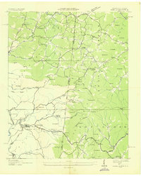
1936 Map of Isabella
USGS Topo · Published 1936About this map
The industrial operations of the Tennessee Copper Company anchor this mid-1930s survey of the copper-rich region near the Tennessee-North Carolina border. The Isabella Mine, Eureka Mine, and the London Flotation Plant dominate the western landscape, linked by the Louisville and Nashville railroad. These mining hubs are surrounded by clustered worker settlements such as Isabella, Stewardtown, and McGeetown. Outside the industrial core, the landscape shifts to the managed timberlands of the Cherokee National Forest, where a network of small churches and schools served isolated rural communities. Features like New Hope Ch, Potato Creek Sch, and the remote Ledfords Store show the pattern of life in the mountains, while numerous gap crossings such as Pack Gap and Franklin Gap reveal the primary routes through the peaks of Angelico Mountain and Shotala Mountain.
Find a feature on this map
82 named features on this map. Tap any name to fly to it.
Don’t see what you’re looking for? This feature index may not catch every label — zoom into the map to look around manually.
Map Details
Editions of this 1936 Isabella Map
This is the sole edition of this map. No revisions or reprints were ever made.
Other maps of this area

1888 · Ellijay
USGS Topo · 1:125,000

1892 · Ellijay
USGS Topo · 1:125,000

1893 · Murphy
USGS Topo · 1:125,000

1898 · Ellijay
USGS Topo · 1:125,000

1911 · Ellijay
USGS Topo · 1:125,000

1914 · Murphy
USGS Topo · 1:125,000

1934 · Persimmon Creek
USGS Topo · 1:24,000

1934 · Unaka
USGS Topo · 1:24,000

1934 · Murphy
USGS Topo · 1:48,000

1935 · Epworth
USGS Topo · 1:24,000