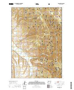
2020 Map of Isham Creek
USGS Topo · Published 2020About this map
The John Day River flows through this portion of Grant County, cutting a path through the southern reaches of the Malheur National Forest. The landscape is defined by an intricate network of drainages and springs, with Eureka Spring, Bumblebee Spring, and Horse Spring providing vital water sources in this high-elevation terrain. Named gulches and draws, such as Eureka Gulch, Cline Draw, and Winegar Gulch, mark the erosion patterns across the forest floor, suggesting the historical movements of early prospectors or ranchers who navigated these drainages.
Find a feature on this map
31 named features on this map. Tap any name to fly to it.
Don’t see what you’re looking for? This feature index may not catch every label — zoom into the map to look around manually.
Map Details
Editions of this 2020 Isham Creek Map
This is the sole edition of this map. No revisions or reprints were ever made.
Other maps of this area

1901 · Sumpter
USGS Topo · 1:125,000

1908 · Ironside Mountain
USGS Topo · 1:125,000

1951 · Bates
USGS Topo · 1:62,500

1955 · Canyon City
USGS Topo · 1:250,000

1959 · Canyon City
USGS Topo · 1:250,000

1959 · Prairie City
USGS Topo · 1:62,500

1972 · Austin
USGS Topo · 1:24,000
1972 · Deardorff Mtn
USGS Topo · 1:24,000
1972 · Little Baldy Mnt.
USGS Topo · 1:24,000

1978 · John Day
USGS Topo · 1:100,000