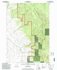
1996 Map of Isham Creek
USGS Topo · Published 1998About this map
The Malheur National Forest boundary defines the landscape of this eastern Oregon region, where steep drainage systems converge toward the John Day River. Private holdings like the Morgan Ranch are situated near the riverbanks, illustrating the historical pattern of homesteading and ranching in the fertile valley bottoms surrounded by public timberlands. Aviation and industry have left subtle marks on the terrain, including a remote Landing Strip and multiple quarries used for local road and resource management.
Find a feature on this map
25 named features on this map. Tap any name to fly to it.
Don’t see what you’re looking for? This feature index may not catch every label — zoom into the map to look around manually.
Map Details
Editions of this 1996 Isham Creek Map
This is the sole edition of this map. No revisions or reprints were ever made.
Other maps of this area

1901 · Sumpter
USGS Topo · 1:125,000

1908 · Ironside Mountain
USGS Topo · 1:125,000

1951 · Bates
USGS Topo · 1:62,500

1955 · Canyon City
USGS Topo · 1:250,000

1959 · Canyon City
USGS Topo · 1:250,000

1959 · Prairie City
USGS Topo · 1:62,500

1972 · Austin
USGS Topo · 1:24,000
1972 · Deardorff Mtn
USGS Topo · 1:24,000
1972 · Little Baldy Mnt.
USGS Topo · 1:24,000

1978 · John Day
USGS Topo · 1:100,000