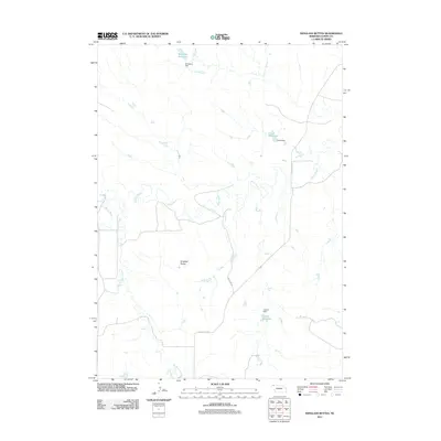
2011 Map of Isinglass Buttes
USGS Topo · Published 2011About this map
White River and Bordeaux Creek define the drainage patterns of this Dawes County landscape, as mapped by the U.S. Geological Survey in the early 21st century. The map reveals a rural infrastructure centered on water management, featuring several privately-named impoundments such as Ormesher Reservoir and Litterel Reservoir. The presence of these reservoirs, alongside their corresponding structures like Jones Dam, indicates a reliance on seasonal water storage for the high plains ranching and agricultural operations common to the Nebraska Panhandle. To the south of the meandering river valley, the namesake Isinglass Buttes rise as a significant landmark, while the local road network is represented by routes like Slim Buttes Rd and Martens Rd, which follow the section lines and natural contours of the territory.
Find a feature on this map
11 named features on this map. Tap any name to fly to it.
Don’t see what you’re looking for? This feature index may not catch every label — zoom into the map to look around manually.
Map Details
Editions of this 2011 Isinglass Buttes Map
This is the sole edition of this map. No revisions or reprints were ever made.
Other maps of this area
1896 · Oelrichs
USGS Topo · 1:125,000
1900 · Oelrichs
USGS Topo · 1:125,000

1955 · Hot Springs
USGS Topo · 1:250,000

1955 · Alliance
USGS Topo · 1:250,000

1957 · Alliance
USGS Topo · 1:250,000

1958 · Alliance
USGS Topo · 1:250,000
1967 · Slim Butte SW
USGS Topo · 1:24,000
1967 · Slim Butte
USGS Topo · 1:24,000
1969 · Chadron NE
USGS Topo · 1:24,000
1969 · Bordeaux
USGS Topo · 1:24,000