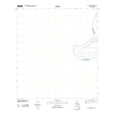
2010 Map of Isla Mesteno
USGS Topo · Published 2010About this map
The Rio Grande snakes through this international border region south of Laredo, defining the physical and political boundary between the United States of America and Mexico. This 2010 survey focuses on the Isla Mesteño area, where the river's meandering course creates distinctive riparian peninsulas and fluvial landforms. The terrain is defined by the shifting hydrology of the border, showing the modern channel as it existed just after the turn of the twenty-first century. While the landscape is largely open, the map documents the critical intersection of natural geography and sovereign limits along the river's edge.
Find a feature on this map
2 named features on this map. Tap any name to fly to it.
Don’t see what you’re looking for? This feature index may not catch every label — zoom into the map to look around manually.
Map Details
Editions of this 2010 Isla Mesteno Map
This is the sole edition of this map. No revisions or reprints were ever made.
Other maps of this area

1933 · Becerra Creek
USGS Topo · 1:62,500

1942 · San Ygnacio
USGS Topo · 1:62,500

1956 · Laredo
USGS Topo · 1:250,000
1979 · Isla Mesteno
USGS Topo · 1:24,000

1979 · Laredo South
USGS Topo · 1:24,000

1979 · O'Keefe Lake
USGS Topo · 1:24,000
1985 · San Ygnacio
USGS Topo · 1:100,000
2010 · Laredo West OE S
USGS Topo · 1:24,000
2010 · Laredo South
USGS Topo · 1:24,000
2010 · Arroyo Salado West
USGS Topo · 1:24,000