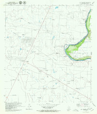
1979 Map of Isla Mesteno
USGS Topo · Published 1979About this map
Rio Bravo Grande carves a tight oxbow across this international borderland, defining the shifting boundary between Webb County, Texas, and Tamaulipas, Mexico. This late 1970s survey documents a landscape of numerous ranching outposts and settlements, from the abandoned site of San Pablo to active hubs like San Isidro (La Campana). The region's economy is etched into the terrain through a network of gas wells and extraction sites, including Oasis Uno and Pandura Tres (Gas), alongside infrastructure like the Guerrero II microwave station. Significant topographical features like Isla Mesteño and the El Lobo drainage reflect the arid environment's drainage patterns. This map serves as a vital record of the border corridor's infrastructure, documenting customs locations such as La Rivereña and the numerous small rancherias that characterize the Webb County backcountry.
Find a feature on this map
56 named features on this map. Tap any name to fly to it.
Don’t see what you’re looking for? This feature index may not catch every label — zoom into the map to look around manually.
Map Details
Editions of this 1979 Isla Mesteno Map
This is the sole edition of this map. No revisions or reprints were ever made.
Other maps of this area

1933 · Becerra Creek
USGS Topo · 1:62,500

1942 · San Ygnacio
USGS Topo · 1:62,500

1956 · Laredo
USGS Topo · 1:250,000

1979 · Laredo South
USGS Topo · 1:24,000

1979 · O'Keefe Lake
USGS Topo · 1:24,000
1985 · San Ygnacio
USGS Topo · 1:100,000
2010 · Laredo West OE S
USGS Topo · 1:24,000
2010 · Laredo South
USGS Topo · 1:24,000
2010 · Arroyo Salado West
USGS Topo · 1:24,000
2010 · O'Keefe Lake
USGS Topo · 1:24,000